| Author |
Message |

bush_pilot
Member
Post Number: 13
Registered: 03-2004
| | Posted on Friday, April 2, 2004 - 3:56 pm: | 

|
Aerial photo of small clear cut west of Sturgeon River near Upper Goose falls. 31 Mar 2004. Ed didn't get over to Aston Lake the other day, hopefully I'll be by that way next weekend.
 |
ed
Moderator
Post Number: 45
Registered: 03-2004

| | Posted on Friday, April 2, 2004 - 4:46 pm: |
|
Thanx Bush Pilot:
I think I might go and walk around that one on the Upper Goose Falls. Is that North or South of the Falls?
Probably can't see it from the River. |
bush_pilot
Member
Post Number: 15
Registered: 03-2004
| | Posted on Saturday, April 3, 2004 - 12:27 am: |
|
Ed
To be honest I wasn't paying that much attention to my exact location but I think the cut is just south of Upper goose. You probably can't see it from the water but as you can see from the photo it is quite close to the river. |
bush_pilot
Member
Post Number: 24
Registered: 03-2004

| | Posted on Tuesday, April 13, 2004 - 10:18 am: |
|
Ed
Here is an example of the logging practices in the Chapleau area. 11 April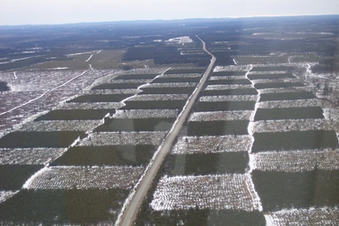 |
martin
Member
Post Number: 2
Registered: 04-2004
| | Posted on Tuesday, April 13, 2004 - 10:49 am: |
|
Wow, they really are turning that area into a huge tree farm (even looks like a farm)! |
paul_hammersten
Member
Post Number: 35
Registered: 03-2004
| | Posted on Tuesday, April 13, 2004 - 11:28 am: |
|
Martin...I second your wow!
A photo is worth a thousand words.
Best
Paul |
alscool
Member
Post Number: 24
Registered: 02-2004

| | Posted on Tuesday, April 13, 2004 - 12:05 pm: |
|
that is called Silvaculture or its a giant game of checkers |
blackfox_dave
Member
Post Number: 10
Registered: 03-2004
| | Posted on Tuesday, April 13, 2004 - 12:33 pm: |
|
Out right discusting thats what I call it.....
All the best Blackfox... |
brooke
Member
Post Number: 2
Registered: 04-2004
| | Posted on Tuesday, April 13, 2004 - 3:49 pm: |
|
I agree. How devastating this is to such a beautiful place. Not to mention, one of the last truly remaining wilderness areas on the planet. May the Lord have mercy on all of us for this abuse to the gifts that He has provided us. Another example of poor land stewardship. BK. |
ed
Moderator
Post Number: 52
Registered: 03-2004
| | Posted on Tuesday, April 13, 2004 - 7:56 pm: |
|
Bush_Pilot:
Nice Pictures! Looks like a farm area in Southern Ontario. Nice flat land that lends itself to that kind of logging. I presume they are farming Black Spruce for high speed paper making but that seems a bit South for that species.
Is that the Sultan road going through there or is it along 101 or 144? It looks too straight for the Sultan.
I guess I don't get so upset about this up there as they do replant and it has been going on in a sustainable fashion for a long time now. Also, I think Spruce are the natural trees that live in that area. As I recall the soil is somewhat sandy in nature, as well as being reasonably flat.
I don't think they will be as successful in turning Temagami forests into tree farms for Aspen, feed stock for OSB , because of the topography there, but I have always wondered why they don't use abandoned farm lands in Southern Ontario as Aspen tree farms. Maybe there is a forester reading this and he could enlighten us.
|
 Temagami general